Naukluft
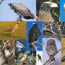
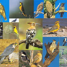
Die Naukluft ist ein großes, vorwiegend unbewohntes Habitat mit einer erstaunlichen ornithologischen Vielfalt. Peter Bridgeford, der hier von 1982 bis 1999 als Naturpark-Ranger arbeitete, zählte über 200 verschiedene Vogelarten.
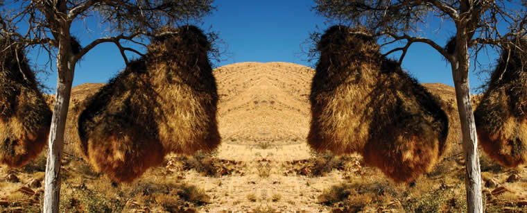
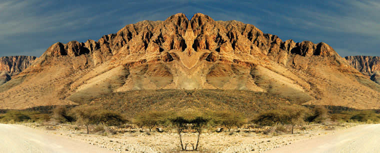
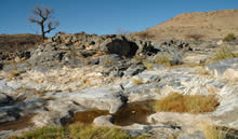
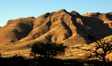
Das Naukluft-Massiv umfasst etwa 2100 qkm und damit 4% der Fläche des Namib-Naukluft-Parks und ist ein landschaftlicher Höhepunkt des Parks. Durch seinen Wasserreichtum in der ansonsten ariden Umgebung ist das Massiv eine unerwartete Oase für Mensch und Tier. Es mangelt hier - im semiariden Klima - nicht nur an Regen, die starken Winde trocknen das Land zusätzlich aus. Ab Ende Januar kann man im Südwesten mit Regen rechnen. Das Massiv verwandelt sich für wenige Monate in ein "grünes" Paradies.
 Das Wasser wird durch den vorherrschende Kalktuff praktisch für das ganze Jahr gespeichert. Der Erfolg ist, dass man auf relativ kleinem Raum ein Vogelparadies von großer Vielfalt finden kann, so auch die in eigentlich feuchteren Gebieten zu erwartenden Arten, wie Graureier, Hammerkopf und Nilgänse.
 Unter der Leitung von Peter Bridgeford wurde in jahrelanger Arbeit eine vollständige Auflistung aller Vogelarten, die der Besucher des Massivs - abhängig von der Jahreszeit mit einigermaßen reellen Chancen sehen kann, erstellt.
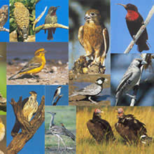 Obwohl über 200 Vogelarten im Massiv nachgewiesen wurden, sind sie nicht die einzige Attraktion, die die Naukluft zu bieten hat. Viele dieser Vogelarten sind in dem Taschenbuch: Namibische Vögel von Ian und Jackie Sinclair (Struik Verlag Kapstadt 2001)
abgebildet und erklärt. Wir empfehlen diese Buch als Feldführer" und für die Vorbereitung zu Hause.
Obwohl über 200 Vogelarten im Massiv nachgewiesen wurden, sind sie nicht die einzige Attraktion, die die Naukluft zu bieten hat. Viele dieser Vogelarten sind in dem Taschenbuch: Namibische Vögel von Ian und Jackie Sinclair (Struik Verlag Kapstadt 2001)
abgebildet und erklärt. Wir empfehlen diese Buch als Feldführer" und für die Vorbereitung zu Hause.http://www.struik.co.za
Liste mit der in der Naukluft vorkomenden Vogelarten Bpyer / Bridgeford: "Birds of the Naukluft Mountains"
NAUKLUFT-experience
- Vision und Konzept für die Gästefarmen Ababis und BüllsPort
Das seit Mai 2004 diskutierte Tourismuskonzept der Gästefarmen Ababis und BüllsPort stellt die Basis für ein langfristige Positionierung der Region mit Hilfe des Markenzeichen NAUKLUFT-experience dar.
NAUKLUFT-experience fühlt sich den Prinzipien, die gemäß Artikel 95 der Namibischen Verfassung darauf abzielen, „das Ökosystem, wesentliche ökologische Prozesse und die Artenvielfalt zu bewahren und lebende, natürliche Ressourcen auf nachhaltige Weise zum Wohle jetziger und künftiger Generationen zu nutzen“ verpflichtet.
Ein wesentliches Element des Konzeptes ist es, die lokale Bevölkerung stärker in den Tourismus einzubeziehen. Dies wird über ein Ausbildungsangebot in Zusammenarbeit mit der Hardap Verwaltung geschehen.
VISION
- Wir sehen NAUKLUFT-experience als Chance für die künftige Entwicklung des lokalen Lebensraumes und seiner Bewohner.
- Das zentrale Anliegen von NAUKLUFT-experience, Natur und Landschaft zukunftsfähig zu erhalten, wollen wir auch in den Bereichen Gesellschaft, der verschiedenen Kulturen seiner Bewohner und Wirtschaft umsetzen.
- Unser Bestreben besteht darin, die Naukluft durch sinnvolles Zusammenwirken aller Bevölkerungsgruppen und der Schaffung von qualifizierten Arbeitsplätzen als eine starke Destination für zukünftige Generationen weiter zu entwickeln und zu erhalten.
- Der Tourismus als der Wirtschaftssektor, aus dem langfristig die für eine selbständig handlungsfähige Entwicklung der Region notwendige Wertschöpfung resultieren wird, soll neue Möglichkeiten für seine Bewohner schaffen.
- Das Markenzeichen NAUKLUFT-experience ist das zentrale Erkennungszeichen für das gesamte Angebot an Tourismusaktivitäten der beteiligten Partner.
Die Entwicklungsziele von NAUKLUFT-experience für den regionalen Tourismus sind:
- Abwechslungsreicher und lebendiger Ganzjahresbetrieb auf der Grundlage unserer landschaftlichen Möglichkeiten. Reisen zwischen Erlebnis, Aktivität und Erholung.
- Einheimische und Gäste kennen, schätzen und schützen die Naturschönheiten der Naukluft. Sie erhalten Informationen über die Geschichte, die unterschiedlichen Kulturen, Fauna und Flora sowie der Geologie der Naukluft.
- Schnelle und kompetente Information über ein internationales Informationssystem (Internet). Die Gästefarmen als Informationstellen im Tal.
- NAUKLUFT-experience mit seinen Angeboten und Stärken ist in den nationalen und internationalen Medien ausreichend präsent.
- Angemessenes Preis-Leistungs-Verhältnis für unsere In- und Ausländischen Gäste.
- Dies alles wird nur erreicht werden können, wenn die Bewohner der Hardap-Region durch Ausbildungsmaßnahmen in das Konzept eingebunden werden.
Naukluft, im Oktober 2004
Für alle Links auf der Homepage von www.naukluft-experience.com gilt:
Mit Urteil vom 12. Mai 1998 - 312 O 85/98 - "Haftung für Links" hat das Landgericht (LG) Hamburg mit Urteil vom 12.5.1998 (AZ 312 O 85/98 - Haftung für Links) entschieden, dass der Betreiber der Seite durch die Schaltung eines Links, die Inhalte der gelinkten Seite ggf. mit zu verantworten hat. Dies kann, lt. LG, nur dadurch verhindert werden, dass der Betreiber sich ausdrücklich von diesen Inhalten distanziert.
Die Arbeitsgemeinschaft NAUKLUFT-experience distanziert sich ausdrücklich von allen Inhalten aller gelinkten Seiten auf dieser Homepage und macht sich diese Inhalte nicht zu eigen. Diese Erklärung gilt für alle auf dieser Homepage angebrachten Links, sofern diese sich auf dieser Präsenz befinden.
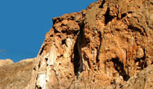
 Das Naukluft-Massiv besteht hauptsächlich aus geklüfteten und verkarsteten Dolomiten und Kalkgesteinen. Der Ursprung des Gebirges ist bis heute noch nicht eindeutig geklärt. Ihre geologischen Geheimnisse und bizarren Strukturen locken viele Besucher an.
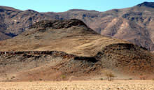 Geologen gehen aber davon aus, dass die Entstehung der Naukluft im ursächlichen Zusammenhang mit der Damaragebirgsbildung vor ca. 550 – 500 Millionen Jahren steht: An der Südflanke des des Damara-Gebirges gelegen, gerieten die Gesteine der heutigen Naukluft-Berge auf dem Höhepunkt der Gebirgsbildung durch druckbedingte „Verflüssigung“ von darunterliegenden, stark salzhaltigen Sedimenten in Bewegung. Auf diesem Gleitmittel wurde das riesige Massiv (immerhin ein Gebirge von 2100 km_ Ausdehnung) durch die bei der Plattenkollision freigesetzten tektonischen Kräfte in einem Stück in südöstliche Richtung in seine heutige
 Position geschoben. Reste des „Schmiermittels“ können Besucher noch heute im Bereich des Gebirges entdecken. Das gelb- bis rotbraune, durch die extreme Beanspruchung stark zerrüttete und zerklüftete Gestein liegt in Bruchstücken am Straßenrand. Aufmerksame Beobachter können an den Hängen nahezu horizontal verlaufende Linien entdecken. Dies ist die ehemalige „Deckengleitbahn“ des Naukluft-Massivs, die sich aus dem beschriebenen salzhaltigen „Schmiermittel“ aufgebaut und die wie eine flache Schüssel das gesamte Naukluft-Gebirige unterlagert
Die Direktorin von Geological Survey of Namibia, Dr. Gabi Schneider, hat in ihrem Buch "The Roadside Geology of Namibia" in dem Kapitel Windhoek – Spreetshoogte Pass – Naukluft – Maltahöhe einen beeindruckenden Text über die geologischen Verhältnisse der Naukluft vorgelegt. Gebr. Borntraeger Verlagsbuchhandlung
Mit diesen Erläuterungen kann bereits die Anfahrt von Windhoek oder Maltahöhe in Richtung Naukluft zu einem geologischen Erlebnis werden.
WINDHOEK-SPREETSHOOGTE PASS - NAUKLUFT – MALTAHÖHE
This route starts in the highlands to the S of Windhoek, follows a spectacular descent of the Great Escarpment via the Spreetshoogte Pass, then borders the Namib Desert before passing the famous Naukluft Mountains to reach Maltahöhe, a total distance of 387 km (Figs 9.5.1, 9.5.2). The first 113 km follow the same route described in 9.4, before turning off to the S on road 1265 in an area underlain by Cenozoic sediments on the farm Göllschau. The Gamsberg Mountain (see 8.10.) is very prominent to the W, while to the E of the road, the Kamelberg mountain range composed of amphibolites of the Elim Formation is visible. Further to the SE, along a thrust, meta-sediments of the Elim and Gaub Valley Formations have been thrust over Gamsberg granite.
Four kilometers from the turn-off, the road enters terrane underlain by Gamsberg granite, with the hills to the east of the road composed of the same granite. There are some granite outcrops fairly close to the road, and after about 2 km, the road takes a marked turn to the W. Here, on the southern side of the road there is a large peneplain underlain by Cenozoic sediments, while some outcrops fairly close and on both sides of the road show the typical onionskin weathering of the Gamsberg granite. This landscape continues for another 2 km, before the road turns S again and eventually enters the peneplain underlain by the Cenozoic sediments. The topography in the vicinity of the road is now quite monotonous, but in the W a mountain range extending S of the Gamsberg is composed of Weener quartzdiorite which intruded meta-sediments of the Gaub Valley Formation.
Some 18 km after the turnoff, the road moves once again into terrane underlain by Gamsberg granite, and shortly thereafter by schist of the Gaub Valley Formation, characterized by large quartz segregations. The road is now approaching the Areb Shear Zone bounded by two major thrusts. Some 7 km further on, after passing some quartzite of the Sinclair Sequence, schist of the Areb Shear Zone thrust onto the quartzite forms a small ridge to the eastern side of the road. After another 5 km this mountain range is now fairly prominent on the western side of the road, but 4 km onwards the road passes the lower boundary thrust of the Areb Shear Zone, and softly undulating hills composed of schist of the Elim Formation occur on the southeastern side of the road. These hills are covered by vegetation and look distinctly different from the hills composed of schist of the Areb Shear Zone seen on the northwestern side of the road. The dark rocks of the Alberta Complex are also now showing in the distance to the W. The Alberta Complex is the most prominent of a series of ultra-mafic bodies that have intruded the Rehoboth Sequence. It covers an area of approximately 100 km² and forms an oval-shaped, intensely faulted body composed essentially of a thick succession of layered gabbroic rocks which was intruded at a later stage by a pegmatoid phase as well as by harzburgite and dunite (DeWaal, 1966). The age of the Alberta Complex has been estimated at 1760 Ma.
The road now passes through an area underlain by Cenozoic sediments, but after 3 km rocky outcrops occur fairly close on either side of the road, with Gamsberg granite on the southeastern side and amphibolites of the Alberta Complex to the northwest. Once the farmhouse on farm Areb is reached after another 6 km, the valley has become fairly narrow with outcrops of Elim Formation schist on either side of the road. Thereafter the road leads through a landscape, underlain by Gamsberg granite, and after 8 kilometers an aplitic variety of that granite forms a few smaller hills on the southern side of the road. Two kilometers further on, road D 1275 to the Spreetshoogte Pass turns off to the N in the vicinity of the old farmhouse and police station.
After the turn-off the road continues in an area underlain by granites of the Piksteel Suite, however, after just one kilometer it crosses an unconformity and once again, Gamsberg granite is the country rock. Slowly, the valley opens, and granite hills, more prominent to the N, can be seen on both sides of the road. Shortly after this the valley narrows once more, and the road winds through an undulating area underlain by Elim Formation schist. Some 9 km after the Spreetshoogte turn-off, the road moves back into granites of the Piksteel Suite, and for some 13 km until the top of the Spreetshoogte Pass, the extremely narrow valley provides numerous good outcrops (Fig. 9.5.3).
The top of Spreetshoogte Pass provides one of the most dramatic views across the Great Escarpment into the Namib Desert. The Great Escarpment here drops to the Namib plains of the Ubib basin below. The red dunes of the main Namib Sand Sea can be seen in the distance. In the middle distance, numerous pans dot the pedogenic calcrete which caps either conglomerate deposits of the Karpfenkliff Formation or sandstones of the Tsondab Formation. The Tsondab Formation (see 8.4) represents an early arid phase in the Namib Desert between 10 and 20 Ma ago, and testifies to the antiquity of the Great Escarpment. To the N-NW, extensive thrusting of the Areb Shear Zone can be observed in a hill, composed of Sinclair Sequence quartzite and rocks of the Areb Shear Zone thrust onto Gamsberg granite.
The descent, one of the steepest down the Great Escarpment with a gradient of 1:4.5, begins in granites of the Piksteel Suite. These granites form the mountains along the Great Escarpment in this area. Spectacular views open up on both sides of the road, as it continues to descend, and moves into an area underlain by young Tsondab Formation sandstones, which becomes immediately noticeable in road outcrops. The bottom of Spreetshoogte, almost 1000 m below the top is reached after just 4 km.
The road now follows a fairly wide valley underlain by Cenozoic sediments. A prominent hill of buff coloured dolomites of the Kudis Subgroup, Damara Sequence, occurs right at the bottom of the pass, and other such dolomite hills occur further down the valley. They support a noticeably different vegetation with resurrection bushes and fig trees. Five kilometers after the bottom of the pass, there is a good view into the Namib Desert in the distance. The high mountains to the SE represent a continuation of the Great Escarpment composed of Piksteel Suite granite. After another 5 km, the prominent V-shaped mountains to the S of the road are made up of Gaub Valley Formation schist intruded by and thrust onto Gamsberg Granite. Some 5 km further on, prominent thrusting of Damaran marble of the Samara Member onto schist of the Gaub Valley Formation is clearly visible in a smaller hill W of the road. Shortly the road turns to the W, and the hills on the southern side of the road are dominated by schist of the Gaub Valley Formation, intensely intruded by granite and diabase dykes, which produce easily noticeable rubble fans of dark boulders. Two kilometers further on the intrusive contact between the Gamsberg granite and the Gaub Valley Formation schist can be observed close to the road. After another 6 km a diabase dyke passes within walking distance of the road, boulders of which lie right next to the road.
At this locality in the distance to the N, mountains composed of Damaran marbles, displaying intense thrusting can be seen and to the W, straight ahead of the road, the Namib Sand Sea provides a magnificent view. On the fringe of the Namib Desert, smaller hills of gneisses of the Mooirivier Complex and dolomites of the Vaalgras Subgroup, Damara Sequence, can be observed contrasting with the desert dunes.
The turn-off to the main road C14 from Walvis Bay to Maltahöhe is reached 32 km from the bottom of Spreetshoogte Pass, and the Naukluft Mountains (see 8.22) appear prominently in the south. As the route follows the road C14 towards Solitaire, the Great Escarpment composed of massive Piksteel granodiorite dominates the landscape in the E, with the Naukluft Mountains following in the SE. In the W, the vast peneplain of the Namib Desert can be seen. Solitaire is reached 9 km from the turn-off to the Spreetshoogte Pass.
Some 12 km south of Solitaire, the Noab Rivier, a major tributary to the Tsondab River is crossed, and to the E a mountain representing an outlier of the Great Escarpment and comprising of Piksteel granodiorite at the base, overlain by sediments of the Nama Group, can be observed. In the W, in the middle distance, some mountains composed of Gamsberg granite are visible and two kilometers further on, the Tsondab River is crossed. This river is a major westward drainage in the area originating E of the Naukluft Mountains and supplying water to Tsondab Vlei (see 8.28).
The road enters the Namib Naukluft Park for a short while some 15 km from Solitaire. The Great Escarpment with Piksteel granodiorite is still prominent in the E, however, as the road enters the valley of the Tsondab River, which is the major valley through the Naukluft Mountains, after about 2 km, Gamsberg Granite overlain by well stratified black limestone of the Kuibis Subgroup, Nama Group, occurs on both sides of the road. These lithologies follow the road for the next 8 km, and exhibit some spectacular intense shearing and deformation, which affected the autochthonous Nama sediments during Naukluft overthrusting (compare 8.22).
The road then turns E, and as the valley widens, the morphology of the mountains also changes. The mountain flanks now comprise green shale of the Pavian Nappe at the bottom, overlain by the gray dolomite of the Kudu Nappe of the Naukluft Complex (see 8.22). The floor of the valley itself is underlain by Cenozoic surficial deposits of sand and calcrete. After 2 km, in a valley to the SW, the contact between the two nappes can be seen halfway up the mountain. The contact is marked by the accumulation of travertine, deposited by springs developed along the contact. These form when meteoric waters percolating through the dolomite encounter the impermeable shale. The waters carry carbonate dissolved from the dolomite, which is then re-deposited, and in this way forming huge “petrified waterfalls”, hence the farm name Blässkranz (compare Fig. 8.22.2).
Some 30 km from Solitaire, a valley branches off to the NE, with its flanks comprising mostly dolomites of the Kudu Nappe. Further on, after about 3 km, the valley widens considerably, and another valley branches off to the W. At the end of this valley, the limestone of the Dassie Nappe is exposed. Next to the road, which now closely follows the Tsondab River, there are abundant outcrops of calcrete. After another 5 km, the road is close to the southern fringe of a fairly wide valley, and the slopes of the mountains to the S contain a variety of lithologies, starting with green shale, boulder shale and white dolomite of the Pavian Nappe at the base, followed by grey dolomite of the Kudu Nappe on top. Massive travertine formation can also be observed. On the northern side of the valley, green shale and boulder shale of the Pavian Nappe are overlain by the massive grey dolomite of the Kudu Nappe.
As the valley slowly narrows, there is an isolated hill right next to the northern side of the road, where green shale of the Pavian Nappe and dolomite of the Dassie Nappe can be seen in outcrop. The road then takes a marked turn to the S, and limestone of the Zebra Nappe, overlain by dolomite of the Dassie Nappe form the mountains to the SW whilst in the NE, dolomite of the Dassie Nappe prevails. Intercalated into these limestones and dolomites is a layer of quartzitic shale of the Zebra Nappe, with again massive travertine development. Some 53 km from Solitaire, the valley almost closes, leaving only a small gap, through which the road leaves the Naukluft Mountains. It then closely follows the Tsondab River with ample exposures of calcrete. The mountains on either side, as well as an isolated hill in the valley are composed of dolomite of the Dassie Nappe and shale and limestone of the Kuibis Subgroup, Nama Group, which have been intensely sheared and deformed during Naukluft over-thrusting. The Büllsport farm house is reached after a further 1 km down the road.
As the road leaves the Naukluft Mountains behind, it follows a very flat peneplain with no outcrop. A few small hills can be seen in the SW and they are composed of shale with thin quartzite layers of the basal Schwarzrand Subgroup of the Nama Group. The landscape itself is underlain by Cenozoic surficial sediments, but some 13 km SE of Büllsport, the road enters terrane underlain by this shale, which is exposed in road cuts. Four kilometers further, the road descends into the small valley of the Nabaseb River, and thereby enters the catchment area of the Hardap Dam. Road cuts provide ample outcrops of shale, as well as the underlying quartzite. Intercalations of finer- and coarser-grained shale can be observed. The following ascent out of the valley also provides road cuts. To the northeast of the road, some flat-topped hills are likewise made up of sediments of the Nama Group.
For the next 20 km the road follows an undulating landscape, interrupted only by the occasional river crossing. The area is underlain by greenish Nama shale and quartzite, exposed in the occasional road cut. Some table-topped hills on both sides of the road are of the same material, capped by greenish and reddish shale. About 37 km from Büllsport, the Kaigab River is crossed, and the road ascends slightly, but still in an area underlain by the shale mentioned before. This is reflected by the darker colouring of the road, due to a difference of the material used in road building.
The road remains in terrane underlain by red shale and quartzite for the next 23 km, however, it slowly ascends to higher stratigraphic levels. Road cuts provide good outcrops in these sediments, which appear fairly massive and red, with finer grained intercalations. About 60 km from Büllsport at Nomtsas farmhouse, the crossing of the Fish River, one of the major drainages in southern Namibia, coincides with a change in the geology. The area is now underlain by reddish shale and sandstone of the upper Schwarzrand Subgroup and the descent and following ascent provide good outcrops in road cuts.
For almost the entire remaining 51 km to Maltahöhe, the road stays in terrane underlain by these reddish Nama sediments. There are river crossings of tributaries of the Fish River, which follows the road to the W, and these provide for limited relief in the otherwise monotonous landscape. Some road cuts, in which intercalations of fine-grained and coarser-grained material can be observed, do occur near these river crossings. Closer to Maltahöhe, the Schwarzrand Escarpment becomes prominently visible in the E and just outside Maltahöhe, the road descends into
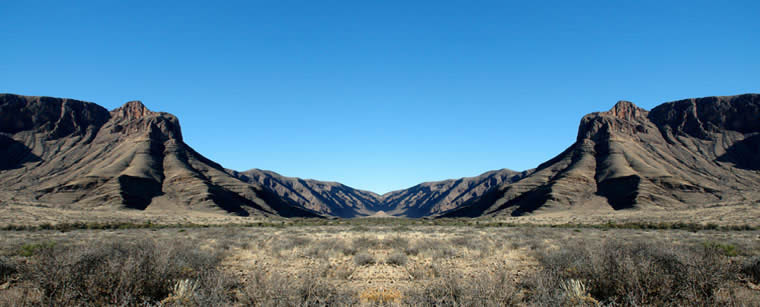
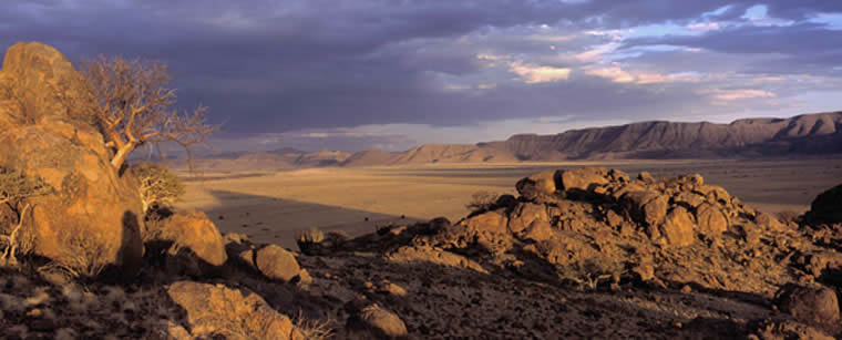
Namensgebend für die Naukluft ist nicht eine „Kloof“,sondern die vielen engen Schluchten im gesamten Massiv – so auch die über 40 km lange von Süd nach Nord verlaufende durchfahrbare Schlucht durch die der Tsondab, ein Trockenrevier, vor mehr als 300 Millionen Jahren sein Bett gegraben hat.
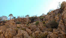
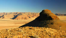
Das Naukluft-Massiv bildet einen sehr prominenten Teil der Randstufe und stellt in Namibia eine geologische Besonderheit dar. Das Gebirge liegt unweit des Wendekreises des Steinbocks am Rande der Namibwüste auf 16° östlicher Länge und 24° südlicher Breite.
Das Massiv ist ein Kalkgebirge, tief zertalt und von elliptischer Form. Das Plateau liegt auf der Steppe wie eine „Platte“, oben flach, an allen Seiten steil. Nur 73 km lang, maximal 27 km breit und ist ca. 2100 qkm groß. Es gibt in Namibia kein anderes Gebirge mit einer so vielgestaltigen Landschaft.
Das eigentliche Naukluft-Gebirge besteht aus sehr alten Gesteinen des Präkambrium, d. h. es ist bis zu einer Milliarde Jahre alt. Die Platte des Gebirges ist aus Kalkstein und wie alle Kalkberge nicht wasserdicht, sondern zerklüftet.
Die Klüfte und Schichtfugen sind durch Lösung zu Kanälen und „Leitungsrohren“ erweitert. Aller Regen, der auf die Decke fällt, sinkt ins Innere und kommt erst an den Seiten oder in den Schluchten wieder hervor. „Die natürlichen Grundwasseraustritte in der Naukluft und ihrer Umgebung“ von Dunja Gaedecke und Judith Kasperski, TU Braunschweig 2004. Dies ist sehr schön bei einer Wanderung durch die Köcherbaumschlucht zu beobachten. Auf der Grenze von Savanne und Wüste ist eine solche Gebirgstafel der natürliche Wasserbehälter. Selbst in gefährlich trockenen Jahren, bilden die immer wasserführenden Quellen für die Umgebung eine Schatzkammer.
Schon vor etwa 300 Millionen Jahren ließ die permokarbone Vereisung [Geologisches Ereignis] ein großes Quertal durch die Naukluft entstehen.
Der engen Schlucht folgt der Tsondab von BüllsPort nach Ababis, der das Gebirge in zwei große Teile teilt. Das periodisch laufende Rivier schafft in Regenzeiten große Wassermassen der etwas feuchteren Ostseite nach Westen auf die blanke Wüste hinaus. Dort versiegen sie zwischen den roten Dünen des Tsondab-Vleis. Die topographische-geologische Kartierung des Gebiets begann im Sommer 1935 durch die deutschen Geologen Hermann Korn und Henno Martin, angeregt durch ihre Lehrer Heinrich Lotz und Hans Cloos. Die Tierwelt des Gebirges ist äußerst vielfältig und sehr artenreich und kann aufgrund des reichlichen Quellwasservorkommens gut beobachtet werden. Insbesondere
die Vogelwelt der Naukluft gilt als spektakulär.
NAUKLUFT-experience sind die Gästefarmen Ababis und Büllsport, die sich im Mai 2004 zu einer Interessengemeinschaft zusammen geschlossen haben
– zwei gute Gründe in die Naukluft zu reisen.
Inmitten der Savannenlandschaft am Fuße der Naukluft liegt die Gästefarm Ababis. Übrigens eine der ältesten Farmen Namibias, sie wurde 1898 als Außenstation des damaligen „Kaiserlichen Landgestüts Nauchas“ aufgebaut. Die Zukunft der Farm sollten aber vor allem Karakulschafe sichern, deren Fell als „Persianer“ in Europa früher die Pelzmode dominierte. Diese Schafrasse hatte ein deutscher Pelzhändler 1907 aus dem zentralasiatischen Buchara in Namibia eingeführt. Aber dieses Land, in dem so selten Regen fällt, taugte nicht für eine profitable Schafzucht. Eine über mehrere Jahre anhaltende Dürre Anfang der achtziger Jahre des vorigen Jahrhunderts machte allen Träumen der Farmer ein Ende. Mit seinem reichlichen Wasservorkommen war Ababis ein beliebter Aufenthaltsort der frühen Bewohner des südwestlichen Afrikas. Felszeichnungen, Steinartefakte, Werkzeuge und Unterschlüpfe zeugen davon, dass Steinzeitmenschen diese Region bewohnten. Heute wird auf Ababis in kleinem Umfang Weidemast mit Rindern und Ziegen betrieben. Der größte Teil der Farm jedoch ist privates Naturschutzgebiet und bietet zahlreichem Wild eine gesicherte Lebensgrundlage. Der Naturschutz auf der 33.000ha großen Farm gilt als vorbildlich. Auf den geführten Farmdrives in das Arebtal können Herden von Hartmann-Bergzebras, Oryx, Kudus und Springböcke beobachtet und fotografiert werden.
BüllsPort liegt auf einer Hochlandfläche direkt
an den gewaltigen Bergen des Naukluft-Massivs unterhalb von Bull’s Mouth. Dieser auffällige Felsen wurde erstmals 1837 auf einem Kupferstich abgebildet, er gab der Farm den Namen. Das Naukluft-Gebirge kann nur an einer Stelle von Süden nach Norden entlang des Tsondab durchquert werden, ein so genanntes Trockenrevier, das ausschließlich bei starken Regenfällen fließt. Am südlichen Eingang dieses Durchgangs befindet sich die Farm, die zur Hälfte im bergigen Gebiet der Naukluft liegt. Johanna & Ernst Sauber, die Gastgeber, züchten erfolgreich Pferde und bieten Ausflüge in der malerischen Landschaft an. Die Felspartien der Naukluft und die eindruckvolle Naturlandschaft lassen sich am besten auf Wanderungen, zum Beispiel durch die Köcherbaumschlucht erleben. Diese gehört zu den Höhepunkten der Aktivitäten rund um die Naukluft. Die Farm ist seit Generationen im Familienbesitz und damit wohl die traditionsreichste Farm im südlichen Naukluftgebiet. Bekannt wurde BüllsPort u.a. durch den Roman „Hans Kiskers Weg nach Südwest“ von Hans Grimm. Hans Kisker betrieb seit 1903 Tierzucht auf BüllsPort. Zu dieser Zeit war die Farm noch Staatsland, auf dem auch ein Polizeiposten stationiert war. Seit Anfang der 1980iger Jahre hat sich der jährliche Niederschlag im Vergleich der davor liegenden 30 Jahre, um 40% verringert. Ernst & Johannas Liebe zu Flora und Fauna sorgte dafür, dass sich dennoch die Wildzahlen und die Artenvielfalt auf dem Farmgelände vergrössert haben. Der Erhalt und Ausbau des Wild-bestandes als angepasster Nutzer der Weide stehen auf BüllsPort seit 1990 im Vordergrund. Heute können die Gäste viele verschiedene Wildarten auf den Wanderungen und Ausflügen aus nächster Nähe sehen. Auf der Farm wird, und das ist wichtig zu wissen, im weiten Umkreis der einzige Store betrieben.